
Garmin Navionics+ & Vision+ Europe, Central & West EU646L

Item: EU646L
MPN: 010-C1275-20
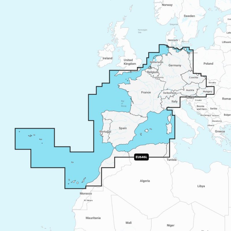
Detailed coverage of central and western Europe. Coverage includes the European coast from the Szczecin Lagoon to Monaco; the Azores; Madeira; the Canary Islands; the Balearics; Corsica and Sardinia; Gibraltar, the English Channel; the Channel Islands; the IJsselmeer; the rivers of France, Germany and the Low Countries; Lakes Maggiore, Como, Garda, Geneva, Constance and Balaton. Supplied on a SD-Card (Micro SD With SD-Card Adapter).
Product Description
EU646L Garmin Navionics+ & Vision+ Europe, Central & WestIt's A Whole New Look On Your Chartplotter
Featuring vibrant colours, a streamlined interface and combined coastal/inland content with a popular Navionics style colour palette, Garmin Navionics+ cartography makes it easy to plot your course with the world's No. 1 name in marine mapping.
Navigate with the best offshore and inland lake coverage for your Garmin chartplotter
See it your way. Customise your view with various chart layers and overlay combinations
With your included one-year subscription, access daily updates via the ActiveCaptain smart device app
Auto Guidance+ technology lets you navigate with suggested dock-to-dock routings
Select up to 10 colour-shaded target depth ranges to scope out the best fishing spots
Features of Both Garmin Navionics+ & Garmin Navionics Vision+
All-In-One map Solution for Garmin Chartplotters
Access detail-rich mapping of coastal features, lakes, rivers and more. Integrated Garmin and Navionics content offers coverage for boaters worldwide.
Daily Chart Updates
Charts are constantly being enhanced with new and amended content - as many as 5,000 updates are made every day. The one-year included subscription gives you access to daily chart updates via the ActiveCaptain smart device app.
Auto Guidance+ Technology
Combining the best of Garmin and Navionics automatic routing features, built-in Auto Guidance+ technology gives you a suggested dock-to-dock path to follow through channels, inlets, marina entrances and more.
Depth Range Shading
High-resolution depth range shading lets you select up to 10 colour-shaded options and view your designated target depths at a glance.
Up to 0.5m Contours
For improved fishing and navigation, up to 0.5 m contours provide a clear depiction of bottom structure for improved fishing charts and enhanced detail in swamps, canals, harbours, marinas and more.
Shallow Water Shading
To give a clear picture of shallow waters to avoid, this feature allows for shading at a user-defined depth.
ActiveCaptain Community
Community-sourced contentprovides useful POIs, such as marinas, anchorages, hazards, businesses and more. Get recommendations from boaters with firsthand experience of the local environment.
--------------------------------------------------------------------------
Features of Garmin Navionics Vision+in addition to Garmin Navionics+
Relief Shading
This detailed shading feature3combines colour and shadow to give you an easy-to-interpret, clearer view of bottom structure than contour lines alone.
High-Resolution Satellite Imagery
High-resolution satellite imagery provides superior situational awareness.
Aerial Photography
Crystal-clear aerial and surface photos of ports, marinas, bridges, docks, boat ramps, dams and navigational landmarks provide a better sense of your surroundings above the waterline.
3D Fisheye View
This underwater perspective shows 3D representation of bottom and contours as seen from below the waterline. Interface with sonar data for a customised view.
3D Marinereye View
This view provides a 3D representation of the surrounding area both above and below the waterline.
Compatibility
The following devices are compatible with Garmin Navionics+ and Garmin Navionics Vision+ cartograghy
ECHOMAP UHD (7" / 9")
ECHOMAP ULTRA (10" / 12")
GPSMAP 10x2 / 12x2
GPSMAP 12x2 Touch
GPSMAP 7x2 / 9x2 / 12x2 PLUS
GPSMAP 7x3 / 9x3 / 12x3
GPSMAP 8400 / 8600 / 8700 BB
## For Devices not listed above please use Garmin BlueChart G3 Charts ##
Collect in Store
This item is available for collection.
People who bought this also bought...